2007 Soaring at Sugarbush, Vermont
Larry Bogan, ACES, Nova Scotia
Sugarbush-Warren, Vermont Airport Sunday, Oct 14 through Saturday, Oct 20.
 This is the fifth year I have flown at Sugarbush, Vermont and the second with the York Soaring expedition. I know that description of the same type of events become boring after awhile so I have given details on just one flight. In 2007 the conditions were very similar to those described for 2006 (See Soaring in Vermont 2006). As in 2006 we had moist conditions and had to contend with overcast conditions in four of the five days of soaring. This year the cloud base was a lower and most ridge flying was below 4000 ft. We again had two days of wave which were cut short by closing cloud decks.
Here is the summary of my flying:
- Sunday, Oct 14 - Ridge soaring on the East Ridge under a solid cloud deck. (no track taken)
- Monday, Oct 15 - Stronger west winds than on Sunday for ridge soaring on the East Ridge including brief wave lift to 5200 ft. Some pilots managed to stay above cloud longer and reached 8,000 and 10,000 ft in wave.
- Tuesday, Oct 16 - This was a clear day with an inversion and small weak thermal lift. I had two short flights of less than an hour.
- Thursday, Oct 18 - There were scattered cumulus clouds mostly over the East Ridge. Cloud base was a little higher at 5000 ft. This was the only day, I flew near the west ridge but could not stay up there.
- Saturday, Oct 20 - There was Wave lift all day but clouds closed in by early afternoon. I flew in the morning and got to 16,200 ft msl and as far as 12 nm north of the airfield - one pilot got to 18,000 ft. As happened in 2006, I had to retreat south and quickly drop through a shrinking hole in the cloud deck to get back to the airport. This produced another exciting flight under the cloud deck back to the field. As an example of wide-spread wave conditions that day, Montreal Soaring council was flying at Lake Placid this weekend and had good wave conditions also (See Lake Placid Blog)
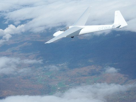
The Wave Flight on Oct 20th. The longest and most enjoyable flight of the week occurred on the last day of our stay in Vermont. The winds were from the southwest about 15 kts and a 2700 ft tow took me to wave lift downwind of Mount Ellen. I climbed at over 6 knots and reached 16,000 ft easily. Peter Rawes and Reinhart Pildner had been the first aloft this day and they flew beside me for Reinhart to take the pictures below at 14,000 ft.
 The patterns of the clouds due to the wave was confusing and at one point it appeared that there was a wave front stretched more or less east to west north of Waitsfield. I tested that and found no lift. Shortly after that a window open in the clouds to the north and I could see past Route I-89 near Waterbury. I started to follow this wave north when it and the cloud opening to the south started to close. It is interesting that I never saw any sign of a hole in the clouds near Mount Mansfield. I headed back and soon there was only one circlar hole open to the south so I headed for that. In the process I discovered that the winds at 15,000 ft were about 50 kts from the southwest. This slowed my progress back dramatically. Finally, at 14,500 ft I pulled spoilers and flew as fast as the Ka-6e is allowed to reach the hole before as it was getting smaller. I decended and circled down through the hole and discovered that I was over a completely wooded area I could not recognize here at 6000 ft. I knew the airfield was to the south (from GPS) but could not see it from there. In fact I should have been able to see Waitsfield but it was not vibible. I flew west and came upon Rt. 100 in the Mad Valley with Waitsfield still to my south and down to 4900 ft msl. In the far distance was the hlll on which the Sugarbush airfield rested. It was 7 nm away and not visible from there but I was relieved to see sufficient fields to land in in case I did not make it to the airfield. I turned south and fortunately was able to find a little ragged lift here and there so that when I got near Mt. Scrag and could easily see the airfield, I was still at 3900 ft. I tried to gain height on the east ridge with ridge lift but it was not working for me and I eventually had to land. Indeed the end of another memorable, exciting two hour flight

 The view from near Mt. Scrag toward Camel's Hump to the north west. This was taken on the Oct 16th when we had clear skies. L.Bogan
For more images of the activities of the York group at Sugarbush in 2007 see the
York Soaring Gallery - Sugarbush 2007
 Sunday, Oct 21 - This may have been a fabulous wave day. We left Vermont in the early morning and had a beautiful, clear, but windy day for travelling east to Fredericton, N.B. We had given thought to staying the extra day if just such a day should occur but I was exhausted from soaring five days and hiking up Mt Abrahams on Friday so could not think of flying that day. Late in the afternoon we saw these beautiful wave clouds downwind of Mt. Katadin in Maine.
Created on ... October 27, 2007 - L.Bogan